 Study the diagram below and read the information that follows to understand the Earth's four spheres.
Study the diagram below and read the information that follows to understand the Earth's four spheres.
The biosphere encompasses parts of the atmosphere, lithosphere, and hydrosphere. Together, they form the life-giving forces of the earth. The biosphere is controlled by the contribution of the other spheres. These contributions form portions of the biosphere called biomes. A biome is a geographical region of plants and animals that are adapted to that particular area. Biomes include deserts, forests, grasslands, tundra, and several types of aquatic environments.
All living things are so closely related to their environment that any change in one part of the environment causes a ripple effect of change through other parts of the environment. Existing within biomes can be one or more ecosystems. The hydrologic cycle is defined as the storage and movement of water between the biosphere, atmosphere, lithosphere, and the hydrosphere. The image above depicts how water moves between the spheres. All water on Earth is stored in one of the following reservoirs: atmosphere, oceans, lakes, rivers, soils, glaciers, snowfields, and groundwater.
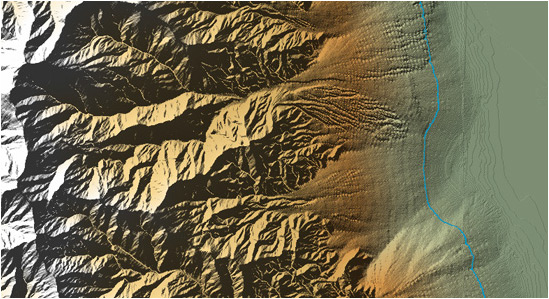
Source: Erosion and Deposition, Physical Geography
Erosion is an example of how the earth's spheres work together. Erosion is a physical process that alters the earth's physical system within the lithosphere. Erosion occurs when landforms on the Earth's surface, such as weathering by wind, water, or ice, are worn or molded.
The image above is a composite image to show the process of erosion. On the left is the Panamint Mountain Range (located on the northern edge of the Mojave Desert in California) and on the right is Death Valley (part of the Mojave Desert in California). The blue line represents an elevation of 0 meters above sea level. The sediments that make up these deposits came from the weathering and erosion of bedrock in the mountains located on the left side of the image. Essentially, the mountains get the rain and other weather which erodes the rock which then flows into the desert.
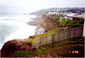
Source: Pacifica, California, January 1998, U.S. Geological Survey.
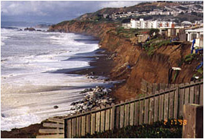
Source: Pacifica, California, February 1998, U.S. Geological Survey.
Activity:
In your notes complete the following activity:
Look at the two pictures above. They are images of the same location, Pacifica, California, taken 34 days apart.